The Ireland Edit
Donegal & the Wild Atlantic North: The Ireland Most Americans Never See
Everyone drives south and west. We drove north. And found the most breathtaking, least crowded, most genuinely Irish corner of the country. This is the trip that changed how we think about Ireland.
Quick Answer
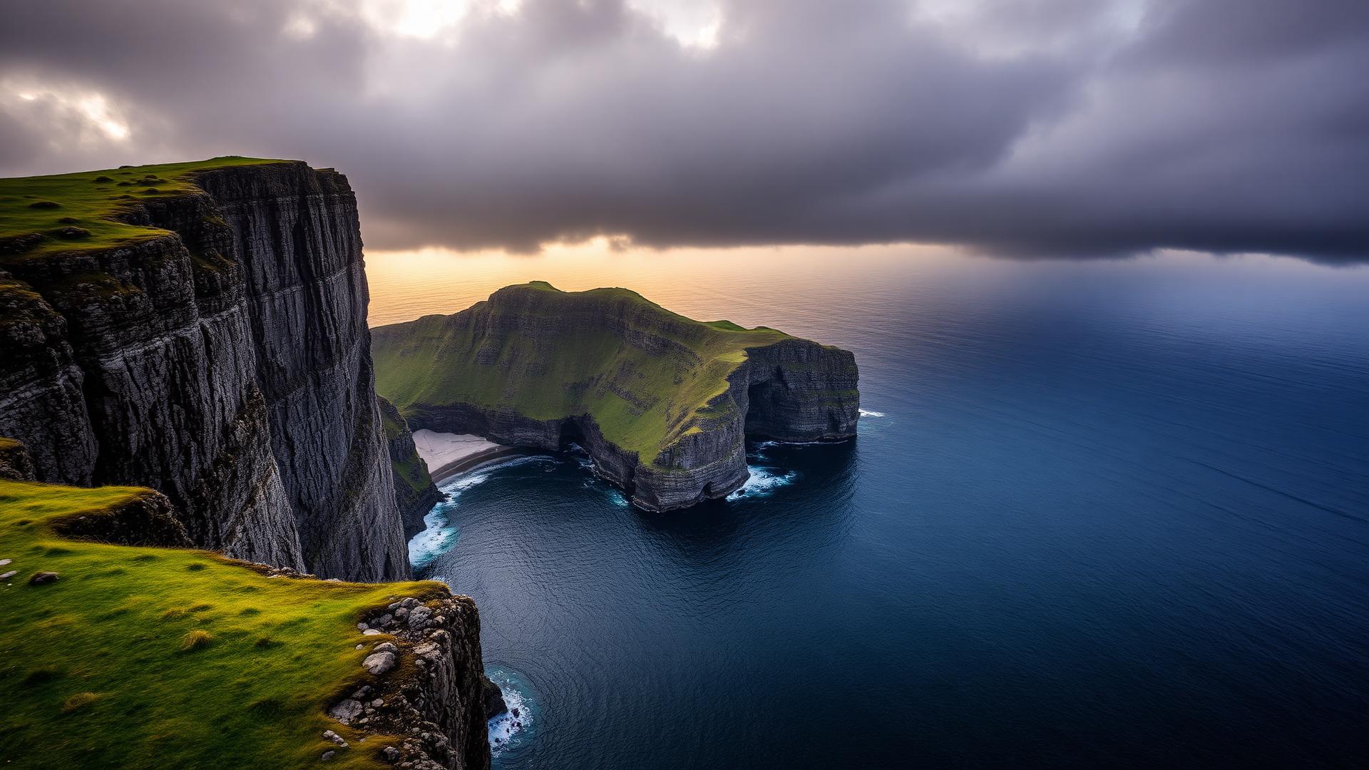
Donegal is Ireland's best-kept secret, and we are only sharing it because it deserves to be seen. Slieve League has sea cliffs twice the height of the Cliffs of Moher with a fraction of the visitors. Fanad Head Lighthouse is the most photogenic building in Ireland. Malin Head is the northernmost point of the island. And the beaches. Murderhole, Portsalon, Maghera. Are among the most beautiful in Europe. Stay at Harvey's Point on Lough Eske, Lough Eske Castle for grandeur, or the boutique Shandon Hotel in Marble Hill. Allow four to five days. Drive from Galway (3 hours) or fly into City of Derry Airport (40 minutes to Donegal town).
For American visitors
Northern Donegal is the emptiest stretch of the Wild Atlantic Way and the reason to come is Slieve League, sea cliffs of about 1,970 feet against 700 feet at the Cliffs of Moher. Give it four to five days, drive roughly 215 miles from Dublin or 130 from Galway, and plan on May, June or September for long light and open roads.
| On the ground in Donegal | What that means for you |
|---|---|
| Slieve League cliff heightAbout 601 metres at the summit | About 1,970 feet. Nearly three times the Cliffs of Moher, and usually a handful of people at the viewpoint. |
| Drive from DublinAbout 345 km on the M3 and N15 | About 215 miles, roughly 3 hours 30 minutes. From Galway it is about 130 miles, close to 3 hours. |
| Days neededFour to five nights, based north and south | Three nights is the floor and it costs you Inishowen. Five lets you do Slieve League, Fanad, Malin Head and Glenveagh without rushing. |
| Best monthsMay, June and September | Long evenings to about 10pm in June, quiet roads, and hotel rates below the July and August peak. |
| Nightly rate, our picksAbout 220 to 450 euro | Roughly 240 to 490 dollars a night for Harvey's Point, Lough Eske Castle or Rathmullan House. |
Related:the Slieve League cliffsour Donegal guidethe Dublin Edit
Two practical notes Americans miss. Malin Head and Inishowen sit close to the Northern Ireland border, so bring a card that handles both euro and pounds, and confirm your rental car is insured for cross-border driving.
Where these numbers come from
- Fáilte Ireland, Wild Atlantic Way: route definition and the Slieve League and Malin Head signature points
- Ordnance Survey Ireland: Slieve League summit elevation
- The Ireland Edit: drive times and nightly rates checked directly with the hotels
Figures last checked . Dollar conversions use a rate of about 1.09 dollars to the euro and 1.27 to the pound, and move with the market.
A note from Deborah. Read her editorial perspective
The north coast, west to east
Northern Donegal in five stages
Donegal is not a loop you finish in a day. This is the order we drive it, with the honest drive times between stops.
| Stage | Drive from previous | Why you stop | Give it |
|---|---|---|---|
| Donegal town and Lough EskeThe southern base | 3 hrs 30 from Dublin, 3 hrs from Galway | Market square, the friary, and the first quiet night by the lake | 1 night |
| Slieve League and KilcarThe reason you came | 1 hr west of Donegal town | 1,970 foot cliffs, the Killybegs harbour catch, Maghera beach caves | Full day |
| Fanad Head and RosguillThe photogenic north | 1 hr 30 north east | Fanad lighthouse, the Atlantic Drive, Murderhole and Portsalon beaches | Full day |
| Malin Head and InishowenThe top of the island | 1 hr 45 east, close to the border | Ireland's northernmost point, Five Finger Strand, the Star Wars headland | Full day |
| Glenveagh National ParkThe inland finish | 1 hr 15 south west | The castle gardens, the lough valley, and a calm last morning | Half day |
Distances look short and take longer than the map suggests. Donegal roads are single carriageway, often single lane, and worth every extra minute.
At a Glance
Quick Picks
| Hotel | Best For | Price Range | |
|---|---|---|---|
| Our PickHarvey's Point | Best luxury lakeside retreat in Donegal | €220–€380/night | Check Availability → |
| Lough Eske Castle | Best castle hotel in the north-west | €250–€450/night | Check Availability → |
| Slieve League Cliffs Tour | Best cliff experience in Ireland (yes, better than Moher) | €50–€90/person | Check Availability → |
| Wild Atlantic Way Private Tour | Best way to see Donegal without driving stress | €350–€500/day | Check Availability → |
Day by Day
Your Itinerary
Arrive in Donegal Town & Settle Into Lough Eske
Donegal Town → Lough Eske
We drove into Donegal from Galway, and the moment we crossed the county line the landscape shifted. The hedgerows got wilder. The mountains got darker. The sky opened up into the kind of vast, cinematic expanse that makes you pull over just to stare. Donegal town is small, handsome, and entirely unpretentious. A diamond-shaped market square, a ruined Franciscan friary by the river, and a handful of pubs where the trad music starts without announcement at around 9pm. We checked into Lough Eske Castle, ten minutes outside town. The castle sits on the edge of a dark lake surrounded by the Bluestack Mountains, and as we walked to dinner the silence was so complete we could hear fish rising in the water. The Cedars Restaurant serves refined Irish cooking. Donegal crab, local lamb, and a cheese board featuring producers most Americans will never have heard of. After dinner we sat by the fire in the oak-panelled library and read. No TV. No noise. Just the fire and the rain on the windows.
Highlights
- •Donegal town. Walk the Diamond, visit the Franciscan friary, browse the craft shops
- •Lough Eske Castle. Arrive, exhale, and let the silence reset you
- •Cedars Restaurant for Donegal crab and local lamb by candlelight
- •Evening: trad music in a Donegal town pub (Reel Inn or The Reveller)
Slieve League: The Cliffs Nobody Told You About
Slieve League → Killybegs
We are going to say something controversial: Slieve League is better than the Cliffs of Moher. The cliffs here are nearly three times the height. 600 metres of sheer rock plunging into the Atlantic. And on the morning we visited, we shared the viewing point with exactly four other people. Four. Try doing that at Moher. The drive from Donegal town takes about an hour through increasingly dramatic countryside. We stopped in Killybegs. Ireland's largest fishing port. For coffee, and watched trawlers unloading the morning catch at the harbour. The smell of salt and diesel and fresh fish is intoxicating. At Slieve League, there are two options: the lower viewing point (easy walk, still jaw-dropping) or the cliff path to the summit (moderate hike, vertigo-inducing, absolutely unforgettable). We did the cliff path. At the top, the wind was ferocious and the views stretched to the Sligo mountains in the south and, on a clear day, to the mountains of Mayo. We stood there for twenty minutes and nobody came. This is why you come to Donegal. For lunch, we drove to Kilcar and ate at the Rusty Mackerel. A stone-walled pub serving fish chowder so good we ordered a second bowl. The afternoon was spent at Maghera Beach, accessible through a series of sea caves at low tide. The beach is deserted, wild, and otherworldly.
Highlights
- •Slieve League sea cliffs. 600m drops, a fraction of Moher's crowds
- •Killybegs fishing harbour. Watch the catch come in, buy smoked salmon
- •Rusty Mackerel pub in Kilcar. The best fish chowder in Donegal
- •Maghera Beach via sea caves. Arrive at low tide for a hidden strand
Fanad Head & the Rosguill Peninsula
Fanad → Rosguill → Downings
If you have ever seen a photograph of Ireland that made you stop scrolling, there is a reasonable chance it was Fanad Head Lighthouse. The lighthouse sits on a rocky headland where Lough Swilly meets the open Atlantic, and on the morning we arrived, the light was doing something impossible. Gold and grey and silver all at once, with the surf exploding against the rocks below. It is the most photogenic building in Ireland, and we have been to all of them. We drove the Fanad Peninsula loop: through tiny villages where Gaelic is the first language, past sheep grazing on cliffs that would give a health-and-safety officer a coronary, and along roads so narrow we had to reverse for a tractor twice. This is the Ireland of fifty years ago, preserved and unpolished. In the afternoon, we drove the Atlantic Drive on the Rosguill Peninsula. A white-knuckle coastal road that makes the Ring of Kerry feel like a motorway. The views from Melmore Head are sensational. We ended the day at Portsalon Beach, consistently rated among the most beautiful beaches in the world by National Geographic. On the day we visited, we had it to ourselves. The water was, admittedly, freezing. The kids did not care.
Highlights
- •Fanad Head Lighthouse. The most photographed spot in Ireland for a reason
- •Fanad Peninsula loop through Gaelic-speaking villages
- •Atlantic Drive on the Rosguill Peninsula. Dramatic, narrow, unforgettable
- •Portsalon Beach. National Geographic's world-class beach, zero crowds
Malin Head & the Inishowen Peninsula
Inishowen Peninsula → Malin Head
Malin Head is the northernmost point of the island of Ireland, and standing there with the wind in your face and nothing between you and Iceland, you understand why the Ancient Order of Hibernians built a tower on this spot. The drive up the Inishowen Peninsula is spectacular. Through Buncrana, along the shores of Lough Swilly, past the stone fort of Grianán of Aileach (a 5,000-year-old circular fort on a hilltop with 360-degree views that would make a drone pilot weep), and finally to Malin Head itself. We arrived on a morning when the weather was doing its Donegal thing. Sideways rain, then sudden sunshine, then a rainbow so vivid it looked artificial. The Wee House of Malin. A hermit's rock shelter at Banba's Crown. Is worth the scramble. Lunch was at Nancy's Barn in Ballyliffin, where the seafood chowder comes with soda bread baked that morning. In the afternoon, we walked Lagg Beach. A vast, windswept strand backed by sand dunes where Star Wars was filmed. The dunes are protected habitat, and the birdwatching is extraordinary if you have binoculars.
Highlights
- •Malin Head. Stand at the northernmost point of Ireland
- •Grianán of Aileach. 5,000-year-old stone fort with 360° panoramic views
- •Nancy's Barn in Ballyliffin. Legendary seafood chowder and soda bread
- •Lagg Beach. Star Wars filming location, vast dunes, rare birds
Glenveagh National Park & Departure
Glenveagh → Letterkenny → Departure
We saved Glenveagh National Park for our last morning, and it was the perfect way to end a Donegal trip. The park covers 170 square kilometres of mountains, bogs, lakes, and native oak woodland. And at its centre sits Glenveagh Castle, a Scottish baronial fantasy built by a Victorian landlord who evicted 244 tenants to create his private estate. The irony is not lost on anyone. The castle gardens are extraordinary: formal Italian terraces, rhododendron walks, and a walled garden that feels like a secret world. We took the shuttle bus from the visitor centre (the walk is 4km if you prefer) and spent two hours exploring the castle, the gardens, and the lakeshore. Red deer graze on the hillside above the lake, and golden eagles. Reintroduced to Donegal in 2001. Circle overhead if you are lucky. We were. After Glenveagh, we drove to Letterkenny for coffee and departed via City of Derry Airport (40 minutes) or continued south toward Sligo and the west coast. This is the trip that changed how we talk about Ireland. Donegal is not a bonus destination. It is the destination.
Highlights
- •Glenveagh National Park. Castle, gardens, mountains, red deer, golden eagles
- •Glenveagh Castle gardens. Formal terraces and walled garden
- •Letterkenny for a final coffee and provisions
- •Depart via City of Derry Airport (40 min) or continue south to Sligo
Book This Day
Small numbers on these dates. Book before you fly.

Road Trip
The Wild Atlantic Way
The Printed Edit
Take The Wild Atlantic Way with you.
The Wild Atlantic Way at the right pace, with the bases we'd actually book.
Built from the drive we send first-timers every week.
A Quiet Word From the Editors
Planning a special trip to Ireland?
Many American readers email us directly while shaping their itinerary. If you're deciding between hotels, regions or routes, we're always happy to point you in the right direction.
Email the editorshello@theirelandedit.com
Common questions
Frequently Asked Questions
Read us on Google
Make The Ireland Edit a preferred source.
See more of our stories, guides and recommendations across Google.